 Catalogue GéoSAS

Type of resources
Available actions
Topics
Keywords
Contact for the resource
Provided by
Years
Formats
Representation types
Update frequencies
status
Service types
Scale
Resolution
-
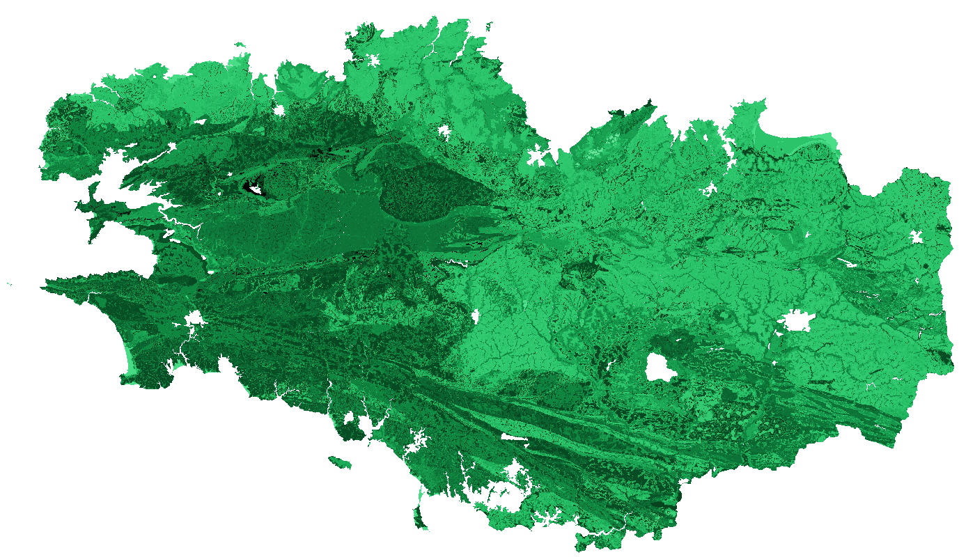
La teneur en carbone organique des sols Bretagne a été estimée pour la région Bretagne à partir du Référentiel Régional Pédologique de Bretagne. Le raster est composé de six bandes, correspondant aux teneurs en carbone organique à six profondeurs standards : 0-15 cm, 5-15 cm, 15-30 cm, 30-60 cm, 60-100 cm et 100-200 cm. Les valeurs sont exprimées en g/kg.
-
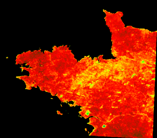
L'Evaporative Fraction (EF) est un indice permettant d'avoir une connaissance relative des zones à fort potentiel hydrique, et inversement, par l'estimation de la capacité d'un sol à évaporer. Cette capacité s'estime via des valeurs allant de 0 (non évaporante) à 1.26 (très évaporante).
-

Les frayères de lamproie marine Petromyzon marinus sont localisées dans le cadre de l'Observatoire Sélune. Cette espèce étant migratrice, sa colonisation de la Sélune et de ses affluents sera probablement influencée par l'effacement des barrages de la Sélune. Les frayères se caractérisent par une dépression accompagnée d’un dôme d’éjection sédimentaire immédiatement en aval. Les pierres retournées sur le dôme sont plus claires ce qui rend les nids facilement visibles et identifiables jusqu’à plusieurs semaines après le frai.
-

Le cours amont de la Sélune n'est pas accessible aux poissons migrateurs du fait des deux barrages hydroélectriques. Les lamproies sont bloquées à une quinzaine de kilomètres de la mer par le premier barrage infranchissable de la Roche qui boit. La méthode utilisée pour échantillonner les lamproies est celle mise au point par Lasne et al. (2010) permettant de prélever plus efficacement les individus de très petite taille que par pêche électrique. La méthode s’appuie sur l’utilisation d’un outil dérivé du filet de Surber, permettant de prélever les ammocètes de façon standardisée. Cette enceinte permet de réaliser des prélèvements ponctuels, à la manière des EPA. La réalisation d’un point de prélèvement se déroule en plusieurs étapes. Après avoir localisé un microhabitat favorable, une caisse est enfouie dans le substrat jusqu’à une profondeur d’environ 15 cm. L’opérateur prélève alors le substrat et le dépose dans le filet. La colonne d’eau dans la caisse est filtrée et les sédiments dans le filet déposés sur un tamis afin de récupérer toutes les ammocètes. Ces dernières sont mesurées et des prélèvements génétiques sont effectués lorsque leur taille le permet. Un total de 30 prélèvements maximum est effectué par station. Cette couche donne la localisation des secteurs d'étude utilisés dans l'échantillonnage des lamproies.
-

Les communautés microbiennes jouent un rôle majeur dans le fonctionnement des écosystèmes : elles sont à la base de la chaîne alimentaire (production primaire) et participent à la dégradation de la matière organique. Ces communautés sont de plus connues pour répondre rapidement à des changements environnementaux. Elles peuvent être utilisées comme indicateurs écologiques, à l'instar des macro-invertébrés. Les diatomées benthiques sont les organismes photosynthétiques majoritaires au sein de cette communauté biologique. L’abondance relative des différentes espèces permet de calculer un indice de qualité du milieu (IBD). Des fortes différences de communautés entre les zones amont et aval ont été constatés quand les barrages étant en place. Elles seront amenées à évoluer après l’effacement de ces barrages. Dans le cadre de l'Observatoire Sélune, les stations sont échantillonnées tous les mois d’Avril à Octobre (7 relevés annuels) à l'aide de substrats artificiels (lames de verre disposées dans l'eau). En plus du relevé des diatomées (liste floristique, calcul de l'IBD), la concentration en chlorophylle a est mesurée. Cette couche donne la localisation des secteurs d'étude utilisés dans le suivi des biofilms photosynthétiques.
-
La teneur médiane de carbone organique par commune des sols Bretagne a été estimée pour la région Bretagne à partir du Référentiel Régional Pédologique de Bretagne. Le vecteur est composé de six bandes, correspondant aux teneurs médiane de carbone organique à six profondeurs standards : 0-15 cm, 5-15 cm, 15-30 cm, 30-60 cm, 60-100 cm et 100-200 cm. Les valeurs sont exprimées en g/kg.
-
Le cours amont de la Sélune n'est pas accessible aux poissons migrateurs du fait des deux barrages hydroélectriques. Les lamproies sont bloquées à une quinzaine de kilomètres de la mer par le premier barrage infranchissable de la Roche qui boit. La méthode utilisée pour échantillonner les lamproies est celle mise au point par Lasne et al. (2010) permettant de prélever plus efficacement les individus de très petite taille que par pêche électrique. La méthode s’appuie sur l’utilisation d’un outil dérivé du filet de Surber, permettant de prélever les ammocètes de façon standardisée. Cette enceinte permet de réaliser des prélèvements ponctuels, à la manière des EPA. La réalisation d’un point de prélèvement se déroule en plusieurs étapes. Après avoir localisé un microhabitat favorable, une caisse est enfouie dans le substrat jusqu’à une profondeur d’environ 15 cm. L’opérateur prélève alors le substrat et le dépose dans le filet. La colonne d’eau dans la caisse est filtrée et les sédiments dans le filet déposés sur un tamis afin de récupérer toutes les ammocètes. Ces dernières sont mesurées et des prélèvements génétiques sont effectués lorsque leur taille le permet. Un total de 30 prélèvements maximum est effectué par station. Cette donnée comprend les abondances observées lors des échantillonnages de lamproies.
-
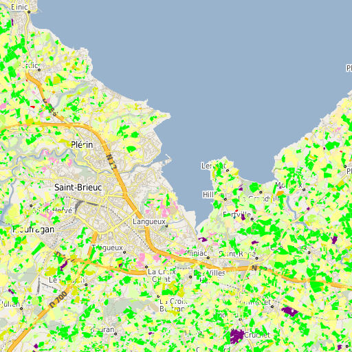
Registre Parcellaire Graphique anonymisé des Côtes d'Armor et rotations culturales de 2006 à 2014. La rotation culturale indiquée correspond à celle de la parcelle principale de chaque ilot déclaré à la PAC en 2014. Travail réalisé par l'UMR AGIR INRA et l'ODR INRA. Un identifiant non signifiant permet de retrouver les ilots d'une même exploitation.
-
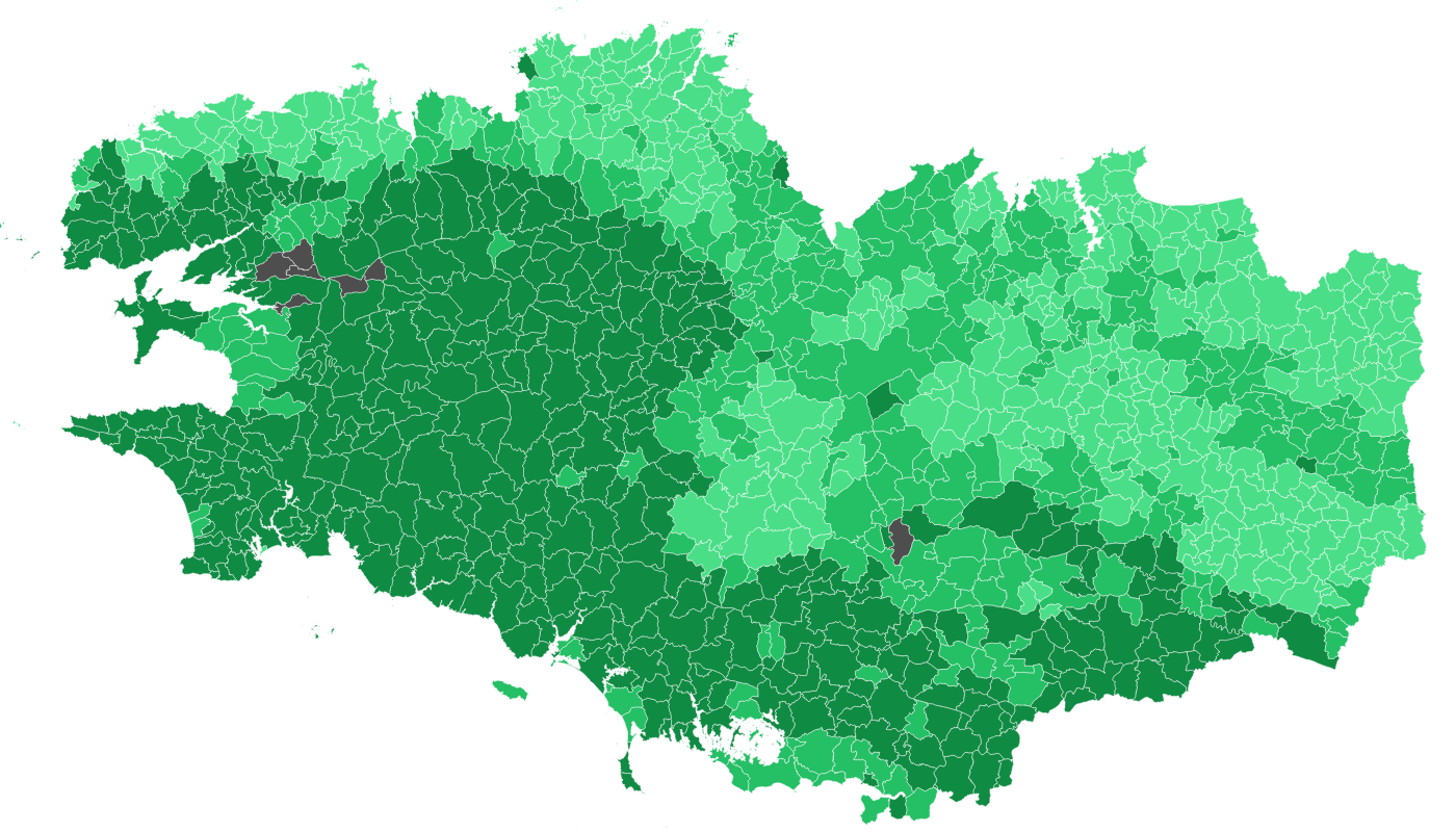
Estimation du stock de carbone (en t/ha) par UCS. Les estimations sont calculées par épaisseur de sol suivant les 4 champs suivants : - Stock_C_10 : estimation entre 0 et 10 cm - Stock_C_30 : estimation entre 0 et 30 cm - Stock_C_50 : estimation entre 0 et 50 cm - Stock_C_1m : estimation entre 0 et 1 m Le numéro d'Unité Typologique de Sol (UCS) issue du Référentiel Régional Pédologique de Bretagne est indiqué dans le champ N_UCS.
-
Soere PRO: Observatoire de la valeur agronomique et des impacts environnementaux des produits résiduaires organiques recyclés en agriculture