 Catalogue GéoSAS
environment
Type of resources
Available actions
Topics
Keywords
Contact for the resource
Provided by
Years
Formats
Representation types
Update frequencies
status
Scale
Resolution
-
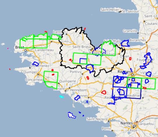
Cette couche représente l'emprise des cartes pédologiques existantes en Bretagne, aux échelles plus fines que le 1/250 000. Ces cartes couvrent environ 45% environ du territoire breton à des échelles allant du 1/100 000 au 1/5 000. Ces cartes ont été réalisées entre 1970 et 1990 pour la plupart, afin de répondre à des thématiques diverses (valeurs es terres agricoles, secteur de référence drainage, connaissance des sols, plans d’épandage…). Ces cartes sont disponibles sous plusieurs formats : image ou vectoriel, avec le cas échéant une table attributaire plus ou moins complète. La légende distingue d'une part le format (nature du trait de contour de la carte pédologique) et d'autre part l'échelle (couleur du trait de contour de la carte pédologique). La table attributaire se compose des champs suivants : - NOM : Nom de la carte composé de sa localisation et de l'échelle correspondante - FORMAT : Format de la carte : scan ou vecteur - ECHELLE : Échelle de la carte - DEPART. : Département(s) dans le(s)quel(s) la carte se situe - DATE : Année de publication de la carte - AUTEUR : Auteur de la carte
-
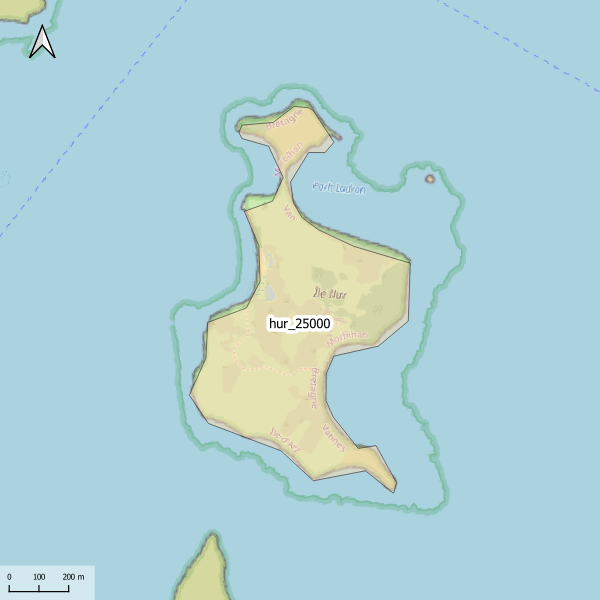
Emprise de la carte pédologique de l'île Ilur au 1/25000. La donnée de base, au format image scannée, n'est pas publiée.
-
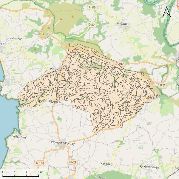
Carte pédologique de Kervijen au 1/25000. La codification correspond au code 4 critères des sols du Massif armoricain (voir ressources en ligne). Les champs de la table attributaire sont : - SUB : Matériau(x) parental(aux) à partir du(des)quel(s) se développe(nt) le sol - HYD : Classe d'hydromorphie, de 0 (sol bien drainé) à 9 (sol extrêmement hydromorphie) - TYPE : Développement de profil défini à partir de la succession des horizons - PROF : Profondeur du sol, classée de 1 (sols très épais) à 6 (sols superficiels) - CODE4C : code 4 critères issu de la concaténation des champs précédents. Les valeurs prises par les différents champs pour chaque entité sont détaillées dans la méthode 4 critères (voir ressources en ligne). - UTS : Numéro d'Unité Typologique de Sol issue du Référentiel Régional Pédologique de Bretagne.
-
L’effacement des barrages de la Sélune fait l’objet d’un programme scientifique initié en 2012 dans lequel des paramètres environnementaux sont suivis afin de fournir un réel retour d’expérience sur cette opération de restauration. En 2019 s’est mis en place un observatoire de données, chargé d’assurer la collecte et le traitement de ces paramètres (biotiques et abiotiques). Les données acquises à partir de 2012 et au moins jusqu’en 2027, seront centralisées grâce à un système d’information (SI), appelé SISelune. SISelune vise à aider les scientifiques associés au programme Sélune et à rendre les données accessibles à tous. Cette couche présente la zone d'étude, basée sur les sous-bassins versants hydrographiques pour la partie continentale, et la masse d'eau de transition pour la baie du Mont St-Michel.
-

Le cours amont de la Sélune n'est pas accessible aux poissons migrateurs du fait des deux barrages hydroélectriques. Les lamproies sont bloquées à une quinzaine de kilomètres de la mer par le premier barrage infranchissable de la Roche qui boit. La méthode utilisée pour échantillonner les lamproies est celle mise au point par Lasne et al. (2010) permettant de prélever plus efficacement les individus de très petite taille que par pêche électrique. La méthode s’appuie sur l’utilisation d’un outil dérivé du filet de Surber, permettant de prélever les ammocètes de façon standardisée. Cette enceinte permet de réaliser des prélèvements ponctuels, à la manière des EPA. La réalisation d’un point de prélèvement se déroule en plusieurs étapes. Après avoir localisé un microhabitat favorable, une caisse est enfouie dans le substrat jusqu’à une profondeur d’environ 15 cm. L’opérateur prélève alors le substrat et le dépose dans le filet. La colonne d’eau dans la caisse est filtrée et les sédiments dans le filet déposés sur un tamis afin de récupérer toutes les ammocètes. Ces dernières sont mesurées et des prélèvements génétiques sont effectués lorsque leur taille le permet. Un total de 30 prélèvements maximum est effectué par station. Cette donnée comprend les abondances observées lors des échantillonnages de lamproies selon les années d'étude 2013, 2015, 2019 et 2021.
-
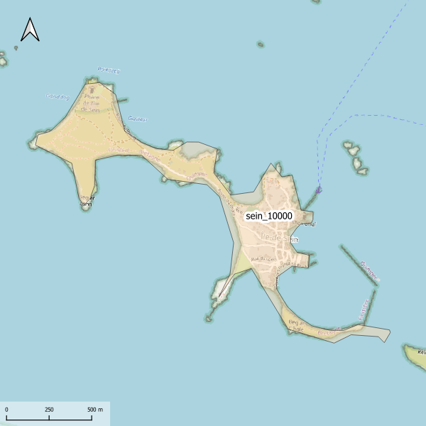
Emprise de la carte pédologique de l'Île-de-Sein au 1/10000. La donnée de base, au format image scannée, n'est pas publiée.
-

Le rétablissement du continuum fluvial de la Sélune après l’arasement des barrages permettra la colonisation de l’amont du bassin anciennement inaccessible aux anguilles. Avant l'arasement, deux affluents principaux étaient utilisés par les poissons amphihalins pour leur reproduction, en plus du cours principal : le Beuvron et l'Oir. La population d’anguilles de la Sélune a été suivie en phase pré-arasement par des campagnes d’indice d’abondance effectuées en 2013, 2015, 2019 sur un réseau de stations couvrant l’ensemble du réseau hydrographique de la Sélune. Depuis 2021, ce réseau de station a évolué pour suivre l'évolution sur la partie du bassin versant accessible suite au démantèlement des 2 barrages. Ces données permettent d’estimer l’évolution de l’abondance des anguilles le long de la Sélune et de ses affluents et leur structuration en taille avant et après la destruction des barrages. L’inventaire est réalisé début septembre, une année sur deux entre 2013 et 2019, puis tous les ans depuis, à l'aide d'un dispositif de pêche électrique et d'épuisettes. Trente points de pêche de trente secondes minimum sont réalisés. Une station de pêche comprend environ 100 mètres de linéaire de cours d’eau. Toutes les anguilles pêchées sont anesthésiées et font l’objet de mesures biométriques (poids, longueur, diamètre oculaire horizontal, vertical, détermination du stade jaune ou argentée). L’ensemble des anguilles est relâché directement sur le site de pêche. Deux protocoles différents mis en œuvre : Indice d’Abondance Anguille (Pottier et Chapon, 2022) sur 23 stations et pêches par épuisement sur 8 autres stations (IAA01 à IAA08) sur le cours d’eau de l’Oir et certains de ses affluents selon un protocole interne. Cette couche fournit les abondances aux stations et ce par session de pêche.
-
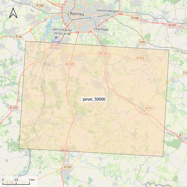
Emprise de la carte pédologique de Janzé au 1/50000. La donnée de base, au format image scannée, n'est pas publiée.
-
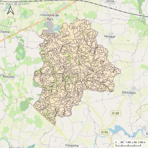
Carte pédologique de Bais au 1/25000. La codification correspond au code 4 critères des sols du Massif armoricain (voir ressources en ligne). Les champs de la table attributaire sont : - SUB : Matériau(x) parental(ux) à partir du(des)quel(s) se développe le sol - HYD : Classe d'hydromorphie, de 0 (sol bien drainé) à 9 (sol extrêmement hydromorphie) - TYPE : Développement de profil défini à partir de la succession des horizons - PROF : Profondeur du sol, classée de 1 (sols très épais) à 6 (sols superficiels) - CODE4C : code 4 critères issu de la concaténation des champs précédents. Les valeurs prises par les différents champs pour chaque entité sont détaillées dans la méthode 4 critères (voir ressources en ligne). - UTS : Numéro d'Unité Typologique de Sol issue du Référentiel Régional Pédologique de Bretagne.
-
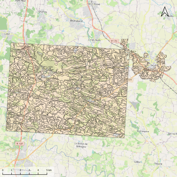
Carte pédologique de Janzé au 1/25000. La codification correspond au code 4 critères des sols du Massif armoricain (voir ressources en ligne). Les champs de la table attributaire sont : - SUB : Matériau(x) parental(ux) à partir du(des)quel(s) se développe le sol - HYD : Classe d'hydromorphie, de 0 (sol bien drainé) à 9 (sol extrêmement hydromorphie) - TYPE : Développement de profil défini à partir de la succession des horizons - PROF : Profondeur du sol, classée de 1 (sols très épais) à 6 (sols superficiels) - CODE4C : code 4 critères issu de la concaténation des champs précédents. Les valeurs prises par les différents champs pour chaque entité sont détaillées dans la méthode 4 critères (voir ressources en ligne). - UTS : Numéro d'Unité Typologique de Sol issue du Référentiel Régional Pédologique de Bretagne.