 Catalogue GéoSAS
dataset
Type of resources
Available actions
Topics
Keywords
Contact for the resource
Provided by
Years
Formats
Representation types
Update frequencies
status
Scale
Resolution
-

Les barrages sont à l’origine de modifications significatives du régime hydrologique, de la température de l’eau et des flux biologiques et biogéochimiques. C’est le cas des barrages de Vezins et de la Roche qui Boit, présents sur le cours principal de la Sélune, et d’autres plus petits obstacles qui fragmentent le bassin versant de la Sélune. Cette couche représente les barrages hydroélectriques de la Sélune, avec les batiments associés, en lien avec la production électrique. La géométrie de ces polygones est issue de plusieurs sources : BD Topo, OpenStreetMap (de 2019), complétée par photointerprétation. Des informations extraites du livre « Quand les rivières reprennent leur cours – Notes sur l’effacement de barrages et de seuils, sur la Sélune et ailleurs » ont été ajoutées pour décrire l'état (en service ou arasé), la nature et les caractérisques physiques de ces barrages.
-

Hyperspectral ENVI standard simulated images. Spatial and spectral configurations generated correspond to ESA SENTINEL-2 instrument that was lunched on 2015, and HYPXIM sensor which was under study at that time.
-

The restoration of the Sélune river continuum after the dams were demolished will allow colonization of the upper reaches of the basin, which were previously inaccessible to eels. Before the demolition, two main tributaries were used by amphihaline fish for reproduction, in addition to the main river: the Beuvron and the Oir. The eel population of the Sélune was monitored in the pre-demolition phase by abundance index campaigns carried out in 2013, 2015, 2019, 2021, and 2023 on a network of stations covering the entire Sélune river system. These data make it possible to estimate changes in eel abundance along the Sélune and its tributaries and their size structure before and after the destruction of the dams. The inventory is carried out in early September, every other year, using electric fishing equipment and landing nets. Thirty fishing points are carried out for a minimum of 30 seconds each. A fishing station covers approximately 100 meters of river. All eels caught are anesthetized and undergo biometric measurements (weight, length, horizontal and vertical eye diameter, determination of yellow or silver stage). All eels are released directly at the fishing site. This layer contains individual data on the eels caught.
-

Le territoire régional est composé de taches urbaines de différentes tailles et formes, distribuées de manière variée. Les espaces urbains sont reliés les uns aux autres par le réseau routier, en particulier le réseau composé des routes primaires et secondaires. Cet espace urbain et routier ainsi composé est fortement artificialisé avec une forte composante d’imperméabilisation qui perdure au fil du temps. La dynamique spatiale et temporelle de cet espace peut être évaluée par les surfaces qui deviennent artificialisées, par la consommation des surfaces interstitielles, généralement agricoles ou naturelles. Ces surfaces à faible imperméabilisation, moins artificialisées, sont ainsi des îlots séparés les uns des autres par la trame urbaine et routière. Ces ilots sont de tailles variées et composent une structure fragmentée.Cet indice prend la forme d'une taille effective de maille, à savoir une grandeur qui exprime « la probabilité que deux points choisis au hasard dans un territoire [...] ne soient pas séparés par des obstacles tels que les voies de communication ou des zones bâties » (J. Jaeger, 2007).
-
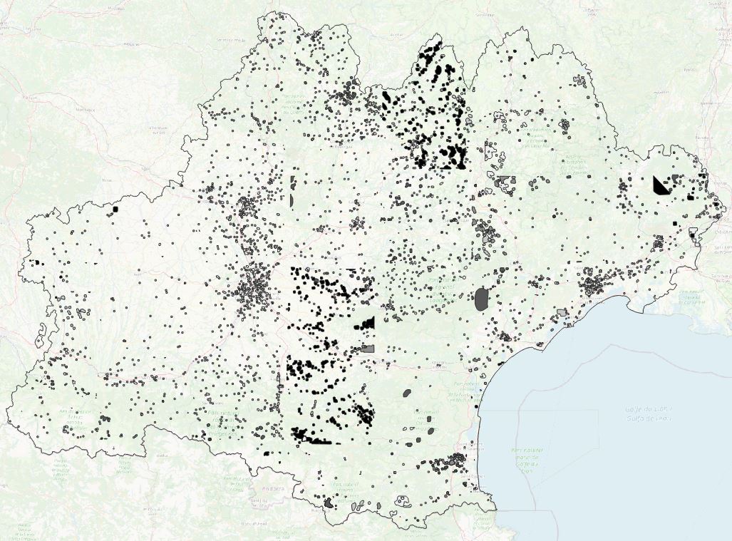
Les données de nodata par année (entre 2015 et 2019) correspondent aux zones de nuages et de leurs ombres portées sur les images satellites SPOT 6/7 utilisées pour la classification d'occupation du sol, donnée source pour les analyses géographiques qui ont suivi (extraction des espaces bâtis, des taches urbaines, indicateurs spatialisés)
-
Full hyperspectral VNIR-SWIR ENVI standard image obtained from the coregistration of both VNIR and SWIR ones through a signal aggregation process that allowed to obtain a synthetic VNIR 1.6 m spatial resolution image, with pixels exactly corresponding to natif SWIR image ones. First, a spatially resampled 1.6 m VNIR image was built, where output pixel values were calculated as the average of the VNIR 0.8 m pixel values that spatially contribute to it. Then, ground control points (GCP) were selected over both images and SWIR one was tied to the VNIR 1.6 m image using a bilinear resampling method using ENVI tool. This lead to a 1.6 m spatial resolution full VNIR-SWIR image.
-

The restoration of the Sélune river continuum after the dams were demolished will allow colonization of the upper reaches of the basin, which were previously inaccessible to eels. Before the demolition, two main tributaries were used by amphihaline fish for reproduction, in addition to the main river: the Beuvron and the Oir. The eel population of the Sélune was monitored in the pre-demolition phase by abundance index campaigns carried out in 2013, 2015, 2019, and then every year since 2021, on a network of stations covering the entire Sélune river system. These data make it possible to estimate changes in eel abundance along the Sélune and its tributaries and their size structure before and after the destruction of the dams. The inventory is carried out in early September, every other year, then every year since 2021, using electric fishing equipment and landing nets. Thirty fishing points are carried out for a minimum of 30 seconds. A fishing station covers approximately 100 meters of river. All eels caught are anesthetized and undergo biometric measurements (weight, length, horizontal and vertical eye diameter, determination of yellow or silver stage). All eels are released directly at the fishing site. This sheet refers to two layers, one showing only the study areas and their location, and the other specifying the concept of capture sessions.
-
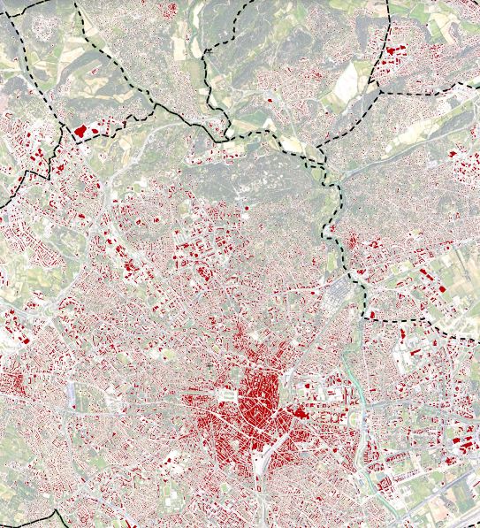
Les cartographies des espaces bâtis sur la région Occitanie résultent d'une extraction automatique par méthode d'apprentissage profond (deep learning) à partir d'imagerie très haute résolution spatiale (1.5m) SPOT 6/7, pour les années 2015 à 2019. Fichiers fournis sous forme vectorielle. (2021-09-09)
-

L'atlas cartographique offre un aperçu des données produites et traitées dans le cadre du projet Artisols. Ce dernier, soutenu par la Région Occitanie et le Fonds Européen de Développement Régional (FEDER), s’inscrit dans une démarche d’évaluation et de qualification du processus d’artificialisation des sols en région Occitanie.Neuf grandes thématiques y sont développées : - Les bâtiments résidentiels et d’activité- L’occupation du sol - La densité de bâti par maille de 150 m de côté - L'évolution de la densité de bâti entre 2017 et 2019- Les taches urbaines - La densité de bâti au sein des taches urbaines- Le coefficient de dispersion- L'indice de fragmentation des espaces non artificialisés- L'indice de compacité des taches urbaines
-

Dams cause significant changes to the hydrological regime, water temperature, and biological and biogeochemical flows. This is the case for the Vezins and La Roche qui Boit dams, located on the main course of the Sélune River, which resulted in the existence of two reservoirs between 1919 and 2022 for La Roche qui Boit and between 1932 and 2019 for Vezins. Since the end of the last emptying of the La Roche qui Boit dam at the end of 2022, these two lakes no longer exist in the valley landscape. This layer represents the two reservoirs as they were referenced in 2017, i.e. before the start of the dismantling work on the two hydroelectric dams on the Sélune. Among the attribute data associated with these two entities, the length is based on a calculation made by the Sélune project team using the reference points established across the entire watershed (and therefore across the entire course of the Sélune) and their knowledge of the areas of influence of the lakes/natural watercourse.