 Catalogue GéoSAS
Environnement
Type of resources
Available actions
Topics
Keywords
Contact for the resource
Provided by
Years
Formats
Representation types
Update frequencies
status
Service types
Scale
Resolution
-
Les barrages sont à l’origine de modifications significatives du régime hydrologique, de la température de l’eau et des flux biologiques et biogéochimiques. C’est le cas des barrages de Vezins et de la Roche qui Boit, présents sur le cours principal de la Sélune, et d’autres plus petits obstacles qui fragmentent le bassin versant de la Sélune. Cette couche représente les barrages hydroélectriques de la Sélune, avec les batiments associés, en lien avec la production électrique. La géométrie de ces polygones est issue de plusieurs sources : BD Topo, OpenStreetMap (de 2019), complétée par photointerprétation. Des informations extraites du livre « Quand les rivières reprennent leur cours – Notes sur l’effacement de barrages et de seuils, sur la Sélune et ailleurs » ont été ajoutées pour décrire l'état (en service ou arasé), la nature et les caractérisques physiques de ces barrages.
-
Le cours amont de la Sélune n'est pas accessible aux poissons migrateurs du fait des deux barrages hydroélectriques. Les lamproies sont bloquées à une quinzaine de kilomètres de la mer par le premier barrage infranchissable de la Roche qui boit. La méthode utilisée pour échantillonner les lamproies est celle mise au point par Lasne et al. (2010) permettant de prélever plus efficacement les individus de très petite taille que par pêche électrique. La méthode s’appuie sur l’utilisation d’un outil dérivé du filet de Surber, permettant de prélever les ammocètes de façon standardisée. Cette enceinte permet de réaliser des prélèvements ponctuels, à la manière des EPA. La réalisation d’un point de prélèvement se déroule en plusieurs étapes. Après avoir localisé un microhabitat favorable, une caisse est enfouie dans le substrat jusqu’à une profondeur d’environ 15 cm. L’opérateur prélève alors le substrat et le dépose dans le filet. La colonne d’eau dans la caisse est filtrée et les sédiments dans le filet déposés sur un tamis afin de récupérer toutes les ammocètes. Ces dernières sont mesurées et des prélèvements génétiques sont effectués lorsque leur taille le permet. Un total de 30 prélèvements maximum est effectué par station. Cette couche donne la localisation des secteurs d'étude utilisés dans l'échantillonnage des lamproies selon les années d'étude 2013, 2015, 2019 et 2021.
-

Les flux hydrologiques, sédimentaires fins et grossiers, et chimiques sont fortement impactés par la présence des barrages, alors que ces paramètres jouent un rôle majeur sur la qualité des habitats pour les communautés aquatiques. leur suivi sur le long terme est primordial dans le cadre d’une opération de restauration écologique après effacement de barrages. De plus sur la Sélune, le démantèlement s’accompagne d’une gestion spécifique des sédiments pour éviter un transfert massif de sédiments vers l’aval. Le transport des sédiments grossiers est étudié à l’aide de galets marqués par des transpondeurs passifs (pit tags). Ces pit tags ont été introduits dans plusieurs centaines de galets de différentes tailles du fleuve. Leurs déplacements au cours du cycle hydrologique sont suivis à l’aide d’une antenne que l’on déplace manuellement en parcourant la rivière, à raison d’une campagne par an. Cette couche donne les localisations des secteurs d'étude utilisés dans le suivi du transport des sédiments grossiers.
-

Les macrophytes sont un ensemble de plantes aquatiques. Elles se situent à la base de la chaine alimentaire et peuvent fournir un habitat à de nombreuses autres espèces. Dans le cadre de l'observatoire Sélune ont été disposées des stations pilotes le long du cours principal de la Sélune, réparties de l’amont à l’aval des barrages hydroélectriques. Trois stations se situent dans les anciennes retenues des barrages, les deux autres, dites de référence, sont hors zone d'influence des anciens barrages (l'une étant en aval et l'autre en amont). Dans ces stations, les biocénoses aquatiques (incluant macroinvertébrés benthiques, biofilms, macrophytes...) sont suivies. Les paramètres suivis sont la composition spécifique et le recouvrement, sur 8 stations du cours principal situées à l’amont, à l’aval et sur les zones néo-lotiques des communautés de macrophytes. La fréquence du suivi consiste en une campagne annuelle pour les stations hors retenues (S0, S1 et S5) et deux campagnes annuelles (printemps/automne) pour les stations néo-lotiques (S2, S3.4, S4.1 et S6). Le protocole mis en œuvre est le protocole d’échantillonnage des macrophytes et bryophytes suivant la norme NF T90-395 (octobre 2003) qui définit l’IBMR. Les taxa sont prélevés pour être identifiés en laboratoire. Cette couche donne la localisation des secteurs d'étude utilisés dans le suivi des macrophytes ainsi que les campagnes réalisées et la mésologie identifiée sur ces différentes campagne.
-
L’effacement des barrages de la Sélune fait l’objet d’un programme scientifique initié en 2012 dans lequel des paramètres environnementaux sont suivis afin de fournir un réel retour d’expérience sur cette opération de restauration. En 2019 s’est mis en place un observatoire de données, chargé d’assurer la collecte et le traitement de ces paramètres (biotiques et abiotiques). Les données acquises à partir de 2012 et au moins jusqu’en 2027, seront centralisées grâce à un système d’information (SI), appelé SISelune. SISelune vise à aider les scientifiques associés au programme Sélune et à rendre les données accessibles à tous. Cette couche présente la zone d'étude, basée sur les sous-bassins versants hydrographiques pour la partie continentale, et la masse d'eau de transition pour la baie du Mont St-Michel.
-

Le cours amont de la Sélune n'est pas accessible aux poissons migrateurs du fait des deux barrages hydroélectriques. Les lamproies sont bloquées à une quinzaine de kilomètres de la mer par le premier barrage infranchissable de la Roche qui boit. La méthode utilisée pour échantillonner les lamproies est celle mise au point par Lasne et al. (2010) permettant de prélever plus efficacement les individus de très petite taille que par pêche électrique. La méthode s’appuie sur l’utilisation d’un outil dérivé du filet de Surber, permettant de prélever les ammocètes de façon standardisée. Cette enceinte permet de réaliser des prélèvements ponctuels, à la manière des EPA. La réalisation d’un point de prélèvement se déroule en plusieurs étapes. Après avoir localisé un microhabitat favorable, une caisse est enfouie dans le substrat jusqu’à une profondeur d’environ 15 cm. L’opérateur prélève alors le substrat et le dépose dans le filet. La colonne d’eau dans la caisse est filtrée et les sédiments dans le filet déposés sur un tamis afin de récupérer toutes les ammocètes. Ces dernières sont mesurées et des prélèvements génétiques sont effectués lorsque leur taille le permet. Un total de 30 prélèvements maximum est effectué par station. Ce tableau contient les données individuelles sur les lamproies capturées selon les années d'étude 2013, 2015, 2019 et 2021.
-
Un obstacle à l’écoulement est un ouvrage lié à l’eau qui est à l’origine d’une modification de l’écoulement des eaux de surface (dans les talwegs, lits mineurs et majeurs de cours d'eau et zones de submersion marine). Seuls les obstacles artificiels (provenant de l’activité humaine) sont pris en compte. Les données présentées sont issues de la couche de données ObstEcoul_FXX publiée par le SANDRE restreintes spatialement à l'emprise du bassin versant de la Sélune. Les données récupérées ont été mises à jour le 30/07/2024 à partir du flux mentionné ci-dessus et retraités pour compléter le type de l'obstacle avec un champs "nature" de l'obstacle représentant une aggrégation des types identifiés sur les valeurs suivantes : "Barrage", "Buse", "Digue", "Pont", "Seuil" et "Non renseigné". L'aggrégation mise en place pour renseigner le champ "nature" est la suivante : 1/ récupération des types d'obstacles présents sur le bassin versant (champ de la donnée source "CdTypeOuvr"). 2/ récupération des libellés associés dans la référence SANDRE : https://api.sandre.eaufrance.fr/referentiels/v1/nsa/284.csv?outputSchema=SANDREv3.1 3/ Filtre sur ces libellés pour renseigner le nouveau champ "nature" : - si le libellé contient "barrage" alors "nature" est initialisé à "Barrage" - si le libellé contient "buse" alors "nature" est initialisé à "Buse" - si le libellé contient "digue" alors "nature" est initialisé à "Digue" - si le libellé contient "pont" alors "nature" est initialisé à "Pont" - si le libellé contient "seuil" alors "nature" est initialisé à "Seuil" - si le libellé contient "non renseigné" (initialement code vide) alors "nature" est initialisé à "Non renseigné" Les autres champs proposés le jeu de données sont issus du flux SANDRE original mais renommés. La correspondance est fournie dans le dictionnaire de données associé.
-

En 2020 ont été mises en place des placettes scientifiques, matérialisées sur le terrain par des piquets colorés. Ces placettes ont pour objectif de faciliter le suivi scientifique, notamment de la renaturation. Ces placettes représentent des espaces privilégiés pour les scientifiques, où aucun remaniement de sédiments ou de la végétation n'est prévu jusqu'à la fin du programme Sélune.
-
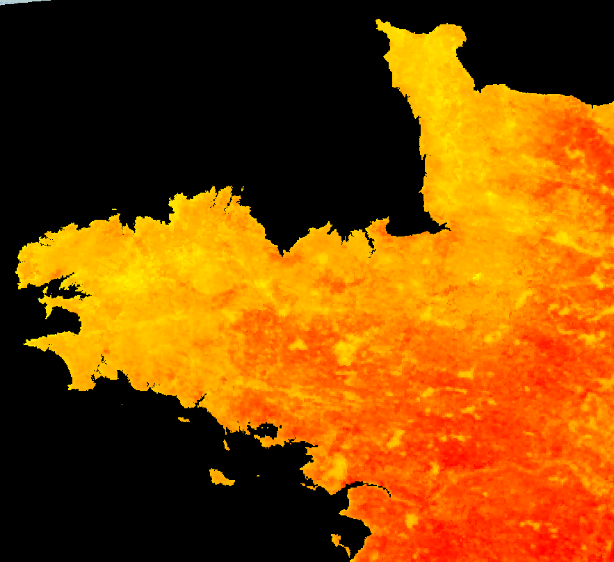
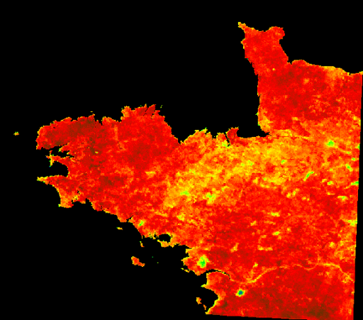
Température moyenne sur 8 jours par ciel clair sur la Bretagne de jour.
-
L'Evaporative Fraction (EF) est un indice permettant d'avoir une connaissance relative des zones à fort potentiel hydrique, et inversement, par l'estimation de la capacité d'un sol à évaporer. Cette capacité s'estime via des valeurs allant de 0 (non évaporante) à 1.26 (très évaporante).