 Catalogue GéoSAS
inlandWaters
Type of resources
Available actions
Topics
Keywords
Contact for the resource
Provided by
Years
Formats
Representation types
Update frequencies
status
Scale
-
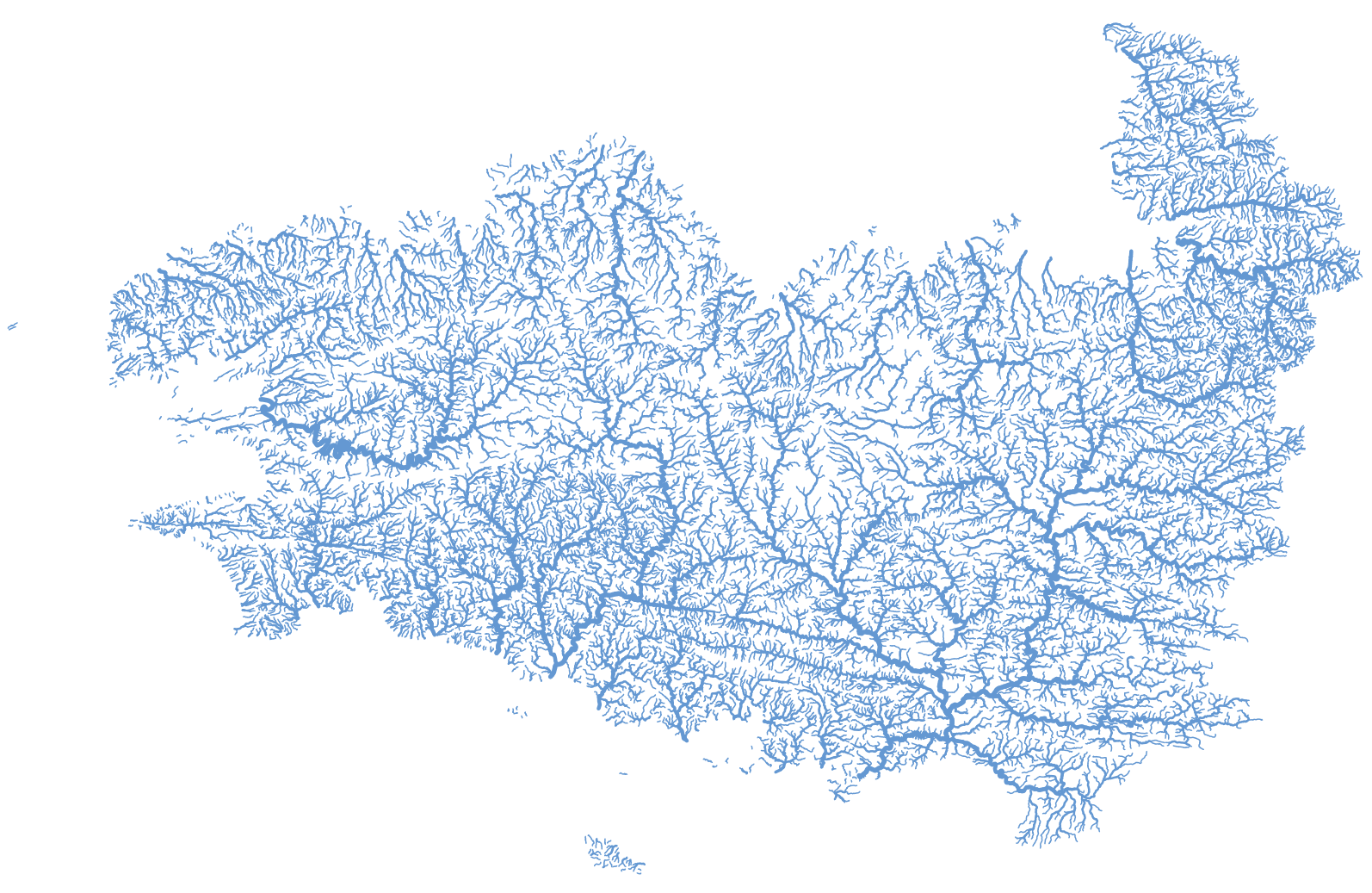
Représentation des tronçons hydrographiques de la Bretagne et des bassins versants de la baie du Mont Saint-Michel extraite de la BD Topage® version 2020. cette couche géographique est corrigée de telle sorte que soit garantie l'unicité du chemin de l'eau de l'amont vers l'aval (suppression des boucles, des canaux, ...).
-
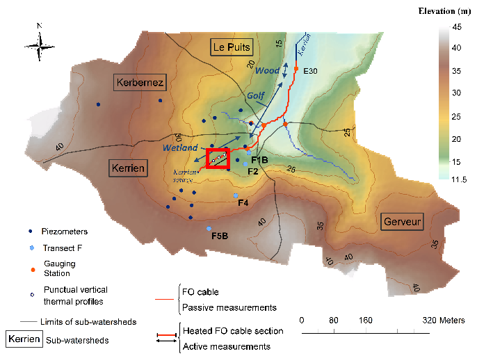
Data corresponding to the active-DTS experiment conducted in Kerrien by deploying and burying an heatable FO cable in the streambed sediments (in the wetland area). Further details are available in the file: http://agrhys.fr/BVE/nataline/mesuresactives/infos.pdf and results are presented in Simon et al. (2021)
-
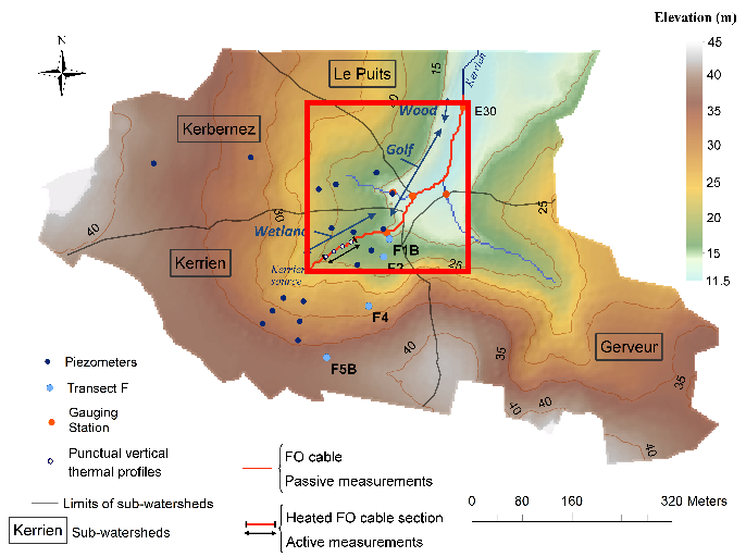
Data corresponds to the long-term monitoring of streambed sediments conducted in Kerbernez through Fiber Optic (FO) DTS technology. The streambed temperature is continuously monitored at high resolution all along the FO cable in order to highlight and quantify groundwater/stream exchanges. Further details are available in the file: http://agrhys.fr/BVE/nataline/mesurespassives/infos.pdf and results are presented in Simon et al. (2021)
-
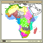
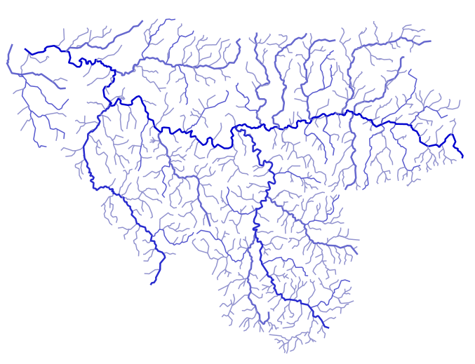
Major hydrological basins and their sub-basins. This dataset divides the African continent according to its hydrological characteristics. The dataset consists of the following information:- numerical code and name of the major basin (MAJ_BAS and MAJ_NAME); - area of the major basin in square km (MAJ_AREA); - numerical code and name of the sub-basin (SUB_BAS and SUB_NAME); - area of the sub-basin in square km (SUB_AREA); - numerical code of the sub-basin towards which the sub-basin flows (TO_SUBBAS) (the codes -888 and -999 have been assigned respectively to internal sub-basins and to sub-basins draining into the sea)
-
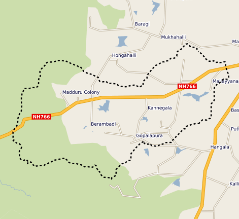
This vector map delineate the boundary of the Berambadi watershed
-
L’effacement des barrages de la Sélune fait l’objet d’un programme scientifique initié en 2012 dans lequel des paramètres environnementaux sont suivis afin de fournir un réel retour d’expérience sur cette opération de restauration. En 2019 s’est mis en place un observatoire de données, chargé d’assurer la collecte et le traitement de ces paramètres (biotiques et abiotiques). Les données acquises à partir de 2012 et au moins jusqu’en 2027, seront centralisées grâce à un système d’information (SI), appelé SISelune. SISelune vise à aider les scientifiques associés au programme Sélune et à rendre les données accessibles à tous. Les cours d'eau sont des entités hydrographique linéaires, liés à un toponyme principal, et décomposés en tronçons hydrographiques. Ces cours d'eau sont extraits de la BD Topage sur l'emprise de la zone d'étude. Des codes, utilisables dans le cadre du programme Sélune ont été ajoutés, ainsi que les codes issus de l'ancien référentiel hydrographique (BD Carthage).
-
Les tronçons hydrographiques, constituants des cours d'eau, ont été extraits de la BD Topage sur l'emprise de la zone d'étude.
-
Les flux hydrologiques, sédimentaires fins et grossiers, et chimiques sont fortement impactés par la présence des barrages, alors que ces paramètres jouent un rôle majeur sur la qualité des habitats pour les communautés aquatiques. leur suivi sur le long terme est primordial dans le cadre d’une opération de restauration écologique après effacement de barrages. De plus sur la Sélune, le démantèlement s’accompagne d’une gestion spécifique des sédiments pour éviter un transfert massif de sédiments vers l’aval. Le transport des sédiments grossiers est étudié à l’aide de galets marqués par des transpondeurs passifs (pit tags). Ces pit tags ont été introduits dans plusieurs centaines de galets de différentes tailles du fleuve. Leurs déplacements au cours du cycle hydrologique sont suivis à l’aide d’une antenne que l’on déplace manuellement en parcourant la rivière, à raison d’une campagne par an. Cette couche donne les localisations des secteurs d'étude utilisés dans le suivi du transport des sédiments grossiers.
-
Un obstacle à l’écoulement est un ouvrage lié à l’eau qui est à l’origine d’une modification de l’écoulement des eaux de surface (dans les talwegs, lits mineurs et majeurs de cours d'eau et zones de submersion marine). Seuls les obstacles artificiels (provenant de l’activité humaine) sont pris en compte. Les données présentées sont issues de la couche de données ObstEcoul_FXX publiée par le SANDRE restreintes spatialement à l'emprise du bassin versant de la Sélune. Les données récupérées ont été mises à jour le 30/07/2024 à partir du flux mentionné ci-dessus et retraités pour compléter le type de l'obstacle avec un champs "nature" de l'obstacle représentant une aggrégation des types identifiés sur les valeurs suivantes : "Barrage", "Buse", "Digue", "Pont", "Seuil" et "Non renseigné". L'aggrégation mise en place pour renseigner le champ "nature" est la suivante : 1/ récupération des types d'obstacles présents sur le bassin versant (champ de la donnée source "CdTypeOuvr"). 2/ récupération des libellés associés dans la référence SANDRE : https://api.sandre.eaufrance.fr/referentiels/v1/nsa/284.csv?outputSchema=SANDREv3.1 3/ Filtre sur ces libellés pour renseigner le nouveau champ "nature" : - si le libellé contient "barrage" alors "nature" est initialisé à "Barrage" - si le libellé contient "buse" alors "nature" est initialisé à "Buse" - si le libellé contient "digue" alors "nature" est initialisé à "Digue" - si le libellé contient "pont" alors "nature" est initialisé à "Pont" - si le libellé contient "seuil" alors "nature" est initialisé à "Seuil" - si le libellé contient "non renseigné" (initialement code vide) alors "nature" est initialisé à "Non renseigné" Les autres champs proposés le jeu de données sont issus du flux SANDRE original mais renommés. La correspondance est fournie dans le dictionnaire de données associé.