 Catalogue GéoSAS
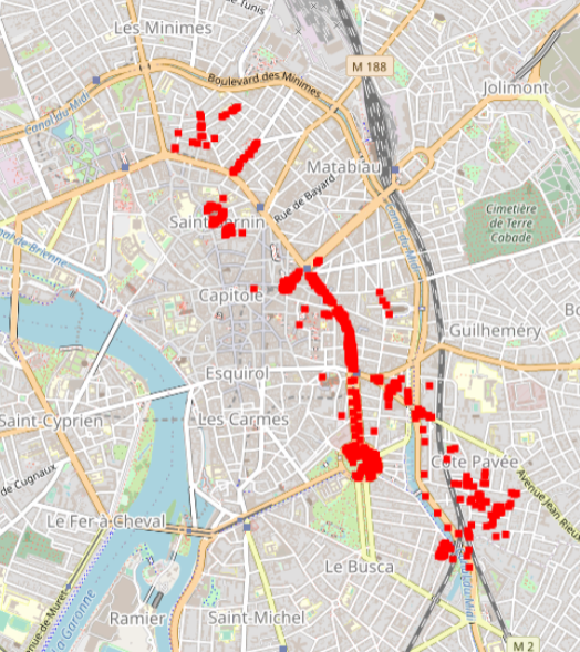
Toulouse 2015 Supervised SVN classification results for 600 urban trees according to a 3 level nomenclature
Hyperspectral data were obtained during an acquisition campaign led on Toulouse (France) urban area on July 2015 using Hyspex instrument which provides 408 spectral bands spread over 0.4 – 2.5 μ. Flight altitude lead to 2 m spatial resolution images. Supervised SVN classification results for 600 urban trees according to a 3 level nomenclature: leaf type (5 classes), family (12 and 19 classes) and species (14 and 27 classes). The number of classes differ for the two latter as they depend on the minimum number of individuals considered (4 and 10 individuals per class respectively). Trees positions have been acquired using differential GPS and are given with centimetric to decimetric precision. A randomly selected subset of these trees has been used to train machine SVM and Random Forest classification algorithms. Those algorithms were applied to hyperspectral images using a number of classes for family (12 and 19 classes) and species (14 and 27 classes) levels defined according to the minimum number of individuals considered during training/validation process (4 and 10 individuals per class, respectively). Global classification precision for several training subsets is given by Brabant et al, 2019 (https://www.mdpi.com/470202) in terms of averaged overall accuracy (AOA) and averaged kappa index of agreement (AKIA).
Simple
- Date ( Révision )
- 2022-05-17T19:09:06
- Edition
- 1.0
- Date d'édition
- 2015-01-01
- Identificateur
- e324c038-08f3-4a11-aca2-7abbeda014e7
Point de recherche
- But
- Provide with urban trees 3 level nomenclature
- Etat
- Finalisé
Point de recherche
- Fréquence de mise à jour
- Non planifiée
- General ( Thème )
-
- remote sensing
- VHRS imagery
- HYPERSPECTRAL imagery
- urban studies
- GEMET - INSPIRE themes, version 1.0 ( Thème )
- GEMET - Concepts ( Thème )
- GCMD Keywords viewer ( Thème )
- TETIS Thesaurus, version 1.0 21112019 ( Thème )
- Limitation d'utilisation
- This work is licensed under a Creative Commons Attribution 4.0 License (CC BY 4.0, https://creativecommons.org/licenses/by/4.0 ).
- Contraintes d'accès
- Licence
- Contraintes d'utilisation
- Licence
- Restrictions de manipulation
- Non classifié
- Explications sur les restrictions
- unclassified
- Système de classification
- no classification in particular
- Description de manipulation
- description
- Type de représentation spatiale
- Vecteur
- Langue
- en
- Jeu de caractères
- Utf8
- Catégorie ISO
-
- Geoscientific information
- Environment
N
S
E
W
))
- Date de début
- 2015-07-01T00:00:00Z
- Date de fin
- 2015-07-31T00:00:00Z
- Informations supplémentaires
- some additional information
- Nom du système de référence
- EPSG / 4326
- Format (encodage)
-
-
ESRI Shapefile
(
1.0
)
-
ESRI Shapefile
(
1.0
)
- Ressource en ligne
- geopackage file ( file for download )
- Ressource en ligne
-
species_27classes
(
OGC:WMS
)
WMS Service
- Niveau
- Jeu de données
Résultat de conformité
- Autres appellations ou acronymes
- This is is some data quality check report
- Date ( Publication )
- 2022-05-17T19:09:06
- Explication
- some explanation about the conformance
- Degré de conformité
- Oui
Résultat de conformité
- Date ( Publication )
- 2010-12-08T12:00:00
- Explication
- See the referenced specification
- Degré de conformité
- Oui
Résultat de conformité
- Date ( Publication )
- 2008-12-04T12:00:00
- Explication
- See the referenced specification
- Degré de conformité
- Oui
- Généralités sur la provenance
- Hyperspectral data were obtained during an acquisition campaign led on Toulouse (France) urban area on July 2015 using Hyspex instrument which provides 408 spectral bands spread over 0.4 – 2.5 μ. Flight altitude lead to 2 m spatial resolution images. Supervised SVN classification results for 600 urban trees according to a 3 level nomenclature: leaf type (5 classes), family (12 and 19 classes) and species (14 and 27 classes). The number of classes differ for the two latter as they depend on the minimum number of individuals considered (4 and 10 individuals per class respectively). Trees positions have been acquired using differential GPS and are given with centimetric to decimetric precision. A randomly selected subset of these trees has been used to train machine SVM and Random Forest classification algorithms. Those algorithms were applied to hyperspectral images using a number of classes for family (12 and 19 classes) and species (14 and 27 classes) levels defined according to the minimum number of individuals considered during training/validation process (4 and 10 individuals per class, respectively). Global classification precision for several training subsets is given by Brabant et al, 2019 (https://www.mdpi.com/470202) in terms of averaged overall accuracy (AOA) and averaged kappa index of agreement (AKIA).
gmd:MD_Metadata
- Identifiant de la fiche
- e324c038-08f3-4a11-aca2-7abbeda014e7 XML
- Langue
- en
- Jeu de caractères
- Utf8
- Identifiant de la fiche de métadonnées parent
- HYEP Project 83867504-286c-4436-b3fc-436ffdc1d912
- Type de ressource
- Jeu de données
- Date des métadonnées
- 2022-05-17T19:25:04
- Nom du standard de métadonnées
- ISO 19115:2003/19139
- Version du standard de métadonnées
- 1.0
Point de contact
Point de recherche
Editeur (publication)
Aperçus
SVN Toulouse urban Trees classification
Fourni par

Ressources associées
Not available