 Catalogue GéoSAS
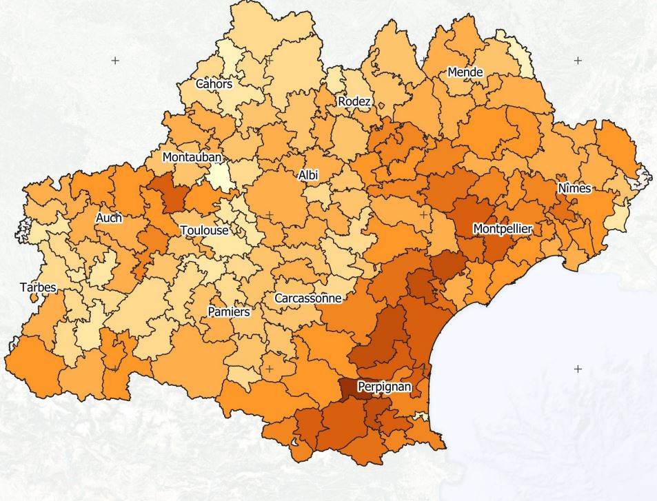
Projet Artisols - Indice de compacité des taches urbaines - 2019
Les taches urbaines distribuées sont caractérisées par des formes très variées. Ces formes peuvent aller d’un aspect très compacte (proche d’un disque, forme de compacité maximale sur un plan) à celui de formes très digitées ou de filaments, s’approchant de lignes plus ou moins sinueuses. Le suivi de cette dimension de compacité morphologique permet d’estimer si l’artificialisation due aux taches urbaines suit des extensions homogènes ou des extensions hétérogènes. Cet indice est calculé à l'échelle des EPCI d'Occitanie et pour l'année 2019.
Simple
- Date ( Révision )
- 2022-05-17T19:10:31
- Edition
- 1.0
- Date d'édition
- 2015-01-01
- Identificateur
- d137e590-f371-46ce-b139-82b48aadd6c3
Point de recherche
- But
- Estimer le mode d'extension urbaine.
- Etat
- Finalisé
Point de recherche
- Fréquence de mise à jour
- Non planifiée
- General ( Thème )
-
- Urban sprawl
- GEMET - INSPIRE themes, version 1.0 ( Thème )
- TETIS Thesaurus, version 1.0 21112019 ( Thème )
- Limitation d'utilisation
- This work is licensed under a Creative Commons Attribution 4.0 License (CC BY 4.0, https://creativecommons.org/licenses/by/4.0 ).
- Contraintes d'accès
- Licence
- Contraintes d'utilisation
- Licence
- Restrictions de manipulation
- Non classifié
- Explications sur les restrictions
- unclassified
- Système de classification
- no classification in particular
- Description de manipulation
- description
- Type de représentation spatiale
- Vecteur
- Langue
- fr
- Jeu de caractères
- Utf8
- Catégorie ISO
-
- Imagery base maps earth cover
N
S
E
W
))
- Date de début
- 2019-01-01T00:00:00Z
- Date de fin
- 2019-12-31T00:00:00Z
- Informations supplémentaires
- some additional information
- Nom du système de référence
- EPSG / 27572
- Format (encodage)
-
-
GPKG
(
1.0
)
-
GPKG
(
1.0
)
- Ressource en ligne
- DOI Indice de compacité des taches artificialisées ( file for download )
- Ressource en ligne
-
Indice_compacite_2019
(
OGC:WMS
)
WMS Service
- Niveau
- Jeu de données
Résultat de conformité
- Autres appellations ou acronymes
- This is is some data quality check report
- Date ( Publication )
- 2022-05-17T19:10:31
- Explication
- some explanation about the conformance
- Degré de conformité
- Oui
Résultat de conformité
- Date ( Publication )
- 2010-12-08T12:00:00
- Explication
- See the referenced specification
- Degré de conformité
- Oui
Résultat de conformité
- Date ( Publication )
- 2008-12-04T12:00:00
- Explication
- See the referenced specification
- Degré de conformité
- Oui
- Généralités sur la provenance
- Cet indice compare la surface d'une tache urbaine à la surface de son cercle circonscrit. Plus l'indice tend vers 1, plus la tache est compacte/circulaire. A l'inverse, plus il se rapproche de 0, plus la tache est digitée.Ici est proposé l’indice de remplissage discal correspondant au rapport entre la surface de la tache urbaine et celle de son cercle circonscrit, selon la formule suivante : Indice = A / π(Rcc)²Avec A : Aire de la tache urbaineRcc : Rayon du cercle circonscrit est la surface totale de l’unité territoriale de reportage.
gmd:MD_Metadata
- Identifiant de la fiche
- d137e590-f371-46ce-b139-82b48aadd6c3 XML
- Langue
- en
- Jeu de caractères
- Utf8
- Identifiant de la fiche de métadonnées parent
- ArtiSols Project 0f2bb3f7-7094-407c-9082-184b667aa577
- Type de ressource
- Jeu de données
- Date des métadonnées
- 2022-05-17T19:23:11
- Nom du standard de métadonnées
- ISO 19115:2003/19139
- Version du standard de métadonnées
- 1.0
Point de contact
Point de recherche
Editeur (publication)
Aperçus
Indice de compacité des taches artificialisées
Fourni par

Ressources associées
Not available