 Catalogue GéoSAS
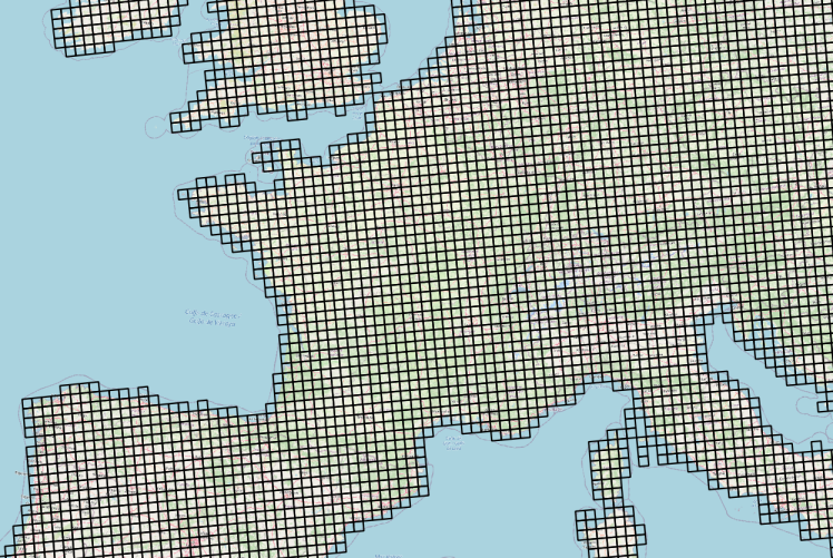
Grille de 25×25 km d'accès aux données météorologiques Agri4cast sur la France
Données météorologiques Agri4cast basées sur des observations et spatialisées sous la forme d'une grille composée de mailles carrées de 625 km² (25 km ×25 km) sur la France.
La table attributaire de cette couche permet d'établir le lien entre l'objet géographique (la maille) et les chroniques d'observation météorologiques via un service conforme au standard OGC SensorThings (https://frost.geosas.fr/agri4cast/v1.0/)
Les observations sont :
- température maximale de l'air (°C),
- température minimale de l'air (°C),
- température moyenne de l'air (°C),
- vitesse moyenne quotidienne du vent à 10 m (m/s),
- pression atmosphérique (hPa),
- précipitations cumulées (mm/jour),
- évapotranspiration potentielle d'un couvert végétal (mm/jour),
- rayonnement global total (KJ/m2/jour).
Les données météorologiques sont quotidiennes de 1979 à la dernière année civile révolue. Plus d’informations sur le portal Agri4cast : https://agri4cast.jrc.ec.europa.eu/DataPortal/Index.aspx
Simple
- Date ( Publication )
- 2022-06-22
- But
- Ce service d'accès aux données météorologiques a été déployé pour simplifier leur intégration dans des modèles et des outils d'aide à la décision. L'idée motrice est de contribuer à la coconstruction d'un écosystème de services numériques pour la science ouverte basé sur les principes du FAIR data et de la directive INSPIRE.
- Reconnaissance
- Joint Research Centre de la Commission Européenne
- Etat
- Mise à jour continue
- Mots clés
-
- données ouvertes
- GEMET - INSPIRE themes, version 1.0 GEMET - INSPIRE themes, version 1.0 ( Thème )
-
- Contraintes d'accès
- Autres restrictions
- Autres contraintes
- Pas de restriction d'accès public
- Limitation d'utilisation
- Usage libre sous réserve des mentions obligatoires sur tout document de diffusion : "Source : Joint Research Centre of the European Commission"
- Limitation d'utilisation
- Licence ouverte V2.0. https://geosas.fr/metadata/pdf/ETALAB-Licence-Ouverte-v2.0.pdf
- Contraintes d'utilisation
- Licence
- Autres contraintes
- Pas de restriction d’accès public
- Type de représentation spatiale
- Vecteur
- Distance de résolution
- 25 km
- Langue
- en
- Jeu de caractères
- Utf8
- Catégorie ISO
-
- Geoscientific information
))
- Date de début
- 1979-01-01
- Date de fin
- 2021-12-31
- Code
- EPSG:3035
- Format (encodage)
-
-
Shapefile
(
1.0
)
-
Shapefile
(
1.0
)
- Ressource en ligne
-
agri4cast_sensorthings
(
OGC:WMS
)
agri4cast_sensorthings
- Ressource en ligne
- Interface de visualisation des données météo ( WWW:LINK-1.0-http--link )
- Ressource en ligne
- Couche géographique de la grille composée de mailles de 25km x 25km ( WWW:DOWNLOAD-1.0-http--download )
- Ressource en ligne
- Service OGC SensorThings Agri4cast ( OGC:STA )
- Niveau
- Jeu de données
Résultat de conformité
- Date ( Publication )
- 2010-12-08
- Explication
- L’article 7, paragraphe 1, de la directive 2007/2/CE correspond aux modalités techniques de l’interopérabilité : il s’agit du règlement relatif à l’interopérabilité : règlement n°1253/2013 du 21 octobre 2013 modifiant et complétant le règlement n°1089/2010 du 23 novembre 2010
- Degré de conformité
- Oui
- Généralités sur la provenance
- Portail Agri4cast. https://agri4cast.jrc.ec.europa.eu/DataPortal/Index.aspx
- Référence du catalogue d'objet
gmd:MD_Metadata
- Identifiant de la fiche
- 643fcbf3-d890-4836-bf62-1204c043bc81 XML
- Langue
- fr
- Jeu de caractères
- Utf8
- Type de ressource
- Jeu de données
- Nom du niveau de hiérarchie
- Parent
- Date des métadonnées
- 2023-12-21T12:00:36
- Nom du standard de métadonnées
- ISO 19115
- Version du standard de métadonnées
- 1.0
Aperçus
Fourni par
