 Catalogue GéoSAS
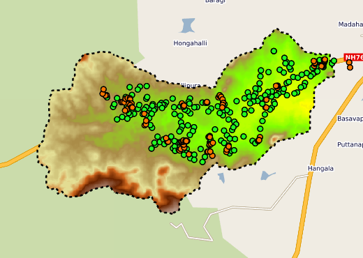
Berambadi site - AICHA Project
International Action AICHA - Adaptation of Irrigated Agriculture to Climate Change in India. Berambadi Site.
Simple
- Date ( Révision )
- 2014-06-27T00:00:00
- Identificateur
- fr-18007003900276-umrsas-aicha-berambadi_site
- Forme de la présentation
- Carte numérique
- But
- In the context of climate change and of agriculture increasingly relying on groundwater irrigation, it is crucial to develop reliable methods for sustainability assessment of current and alternative agricultural systems. The project will develop an integrated model (in agronomy, hydrogeology and economics) and scenarios of evolution of agricultural systems and water management policies will be tested both at the farm scale and the watershed scale in the case of an experimental watershed in Peninsular India. A methodology combining remote sensing, field surveys and inverse modelling for retrieving spatially distributed relevant biophysical parameters, determining factors of cropping systems and socio-economics will be developed. A farmer decision model will be developed to investigate the farming system adaptability to changing climate and economic context.
- Etat
- Finalisé
Point de contact
IFCWS / CEFIRSE BANGALORE INDIA
-
IFCWS / CEFIRSE BANGALORE INDIA
(
)
4 rue Stang Vihan
Quimper
29000
France
- Fréquence de mise à jour
- Lorsque nécessaire
- external.place.thematiques ( Thème )
-
- open data
- watershed
- Mots clés
-
- données ouvertes
- Registre de thème INSPIRE ( Thème )
-
- Caractéristiques géographiques météorologiques
- Installations de suivi environnemental
- Parcelles cadastrales
- Sols
- Hydrographie
- Usage des sols
- Limitation d'utilisation
- You must mention "Source: IFCWS CEFIRSE BANGALORE INDIA" in every public use of the database as well as works produced from this data set.
- Limitation d'utilisation
- ODC-BY 1.0 license : http://opendatacommons.org/licenses/by/summary/
- Contraintes d'accès
- Autres restrictions
- Contraintes d'utilisation
- Brevet
- Type de représentation spatiale
- Vecteur
- Dénominateur de l'échelle
- 25000
- Langue
- eng
- Jeu de caractères
- Utf8
- Catégorie ISO
-
- Farming
N
S
E
W
))
- Informations supplémentaires
-
Champs de la table attributaire
ID: numéro identifiant
Longueur: longueur du segment en mètre
CodeHydro: code hydrologique du cours d'eau (BD Carthage)
ZoneEtude: cours d'eau situé sur la zone d'étude
Régulier: cours d'eau alimenté plus de huit mois dans l'année
(NA: non renseigné)
- Nom du système de référence
- WGS 1984
- Nom du système de référence
- EPSG / RGF93 / Lambert-93 (EPSG:2154) / 7.4
- Format (encodage)
-
-
ESRI shapefile
(
ESRI shapefile
)
-
ESRI shapefile
(
ESRI shapefile
)
- Ressource en ligne
- Portail cartographique du projet AICHA : site Berambadi ( WWW:LINK-1.0-http--link )
- Niveau
- Collection de données
- Généralités sur la provenance
- genealogie bidon
gmd:MD_Metadata
- Identifiant de la fiche
- 42b0d9bd-ce29-43df-98c2-0b14ab19693f XML
- Langue
- fre
- Jeu de caractères
- Utf8
- Identifiant de la fiche de métadonnées parent
- 441894c8-4a05-436a-b849-6d83f8d08bce 441894c8-4a05-436a-b849-6d83f8d08bce
- Type de ressource
- Jeu de données
- Date des métadonnées
- 2026-05-06T18:54:52
- Nom du standard de métadonnées
- ISO 19115:2003/19139
- Version du standard de métadonnées
- 1.0
Point de contact
UMR 1069 SAS INRA - Agrocampus Ouest
-
Contact GéoSAS
(
)
INRA UMR 1069 SAS, 65 rue de St Brieuc - CS 84215
Rennes
35042
France
Aperçus
large_thumbnail
Fourni par

Ressources associées
Not available