 Catalogue GéoSAS
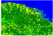
Nippes - Haïti - 2020, Land Cover Map at high spatial resolution
The map described here was produced as part of the Resilient Productive Territories (RPT) project. This project is funded by the World Bank. Reference of the database used to produce these maps: Dupuy, Stéphane; Lelong, Camille; Manasse, Marie Esther; Rambao, Jery; Mondésir, Jacques Philémon; Gaetano, Raffaele, 2021, "Nippes - Haïti - 2020, Reference Spatial Database", doi:10.18167/DVN1/29RZMQ , CIRAD Dataverse,V1
Simple
- Date ( Révision )
- 2022-05-17T19:10:07
- Edition
- 1.0
- Date d'édition
- 2015-01-01
- Identificateur
- 36618a22-1741-4299-94a3-3dbb75859db9
Point de recherche
- But
- The map described here was produced as part of the Resilient Productive Territories (RPT) project. This project is funded by the World Bank. Reference of the database used to produce these maps: Dupuy, Stéphane; Lelong, Camille; Manasse, Marie Esther; Rambao, Jery; Mondésir, Jacques Philémon; Gaetano, Raffaele, 2021, "Nippes - Haïti - 2020, Reference Spatial Database", doi:10.18167/DVN1/29RZMQ , CIRAD Dataverse,V1
- Etat
- Finalisé
Point de recherche
- Fréquence de mise à jour
- Non planifiée
- General ( Thème )
-
- Cartographie de l'occupation du sol
- Classification des sols
- Environnement
- Télédétection
- GEMET - INSPIRE themes, version 1.0 ( Thème )
- GEMET - Concepts ( Thème )
- GCMD Keywords viewer ( Thème )
- TETIS Thesaurus, version 1.0 21112019 ( Thème )
- Limitation d'utilisation
- This work is licensed under a Creative Commons Attribution 4.0 License (CC BY 4.0, https://creativecommons.org/licenses/by/4.0 ).
- Contraintes d'accès
- Licence
- Contraintes d'utilisation
- Licence
- Restrictions de manipulation
- Non classifié
- Explications sur les restrictions
- unclassified
- Système de classification
- no classification in particular
- Description de manipulation
- description
- Type de représentation spatiale
- Vecteur
- Distance de résolution
- 200 m
- Langue
- en
- Jeu de caractères
- Utf8
- Catégorie ISO
-
- Environment
- Imagery base maps earth cover
N
S
E
W
))
- Date de début
- 2020-01-01T00:00:00Z
- Date de fin
- 2020-12-31T00:00:00Z
- Informations supplémentaires
- some additional information
- Nom du système de référence
- EPSG / 2154
- Format (encodage)
-
-
KML
(
1.0
)
-
KML
(
1.0
)
- Ressource en ligne
- DOI ( file for download )
- Niveau
- Jeu de données
Résultat de conformité
- Autres appellations ou acronymes
- This is is some data quality check report
- Date ( Publication )
- 2022-05-17T19:10:07
- Explication
- some explanation about the conformance
- Degré de conformité
- Oui
Résultat de conformité
- Date ( Publication )
- 2010-12-08T12:00:00
- Explication
- See the referenced specification
- Degré de conformité
- Oui
Résultat de conformité
- Date ( Publication )
- 2008-12-04T12:00:00
- Explication
- See the referenced specification
- Degré de conformité
- Oui
- Généralités sur la provenance
- The maps were produced with iota2 processing chain, developed in the framework of the activities of the "Land Use" Scientific Expertise Centre of the Theia Data and Services Center. They are distributed in raster TIFF format. IOTA2 produces land cover maps by classifying satellite images. It implies a time series of Sentinel 2 images a Digital Terrain Model, and a field reference database. This sheet therefore contains maps produced at each different precision level of the nomenclature:The most detailed level, labelled Code2, is composed of 12 classes. The basic level, labelled Code1, is composed of 8 classes. The level labelled Code0 is a proposal of slightly different distribution of classes at the same level than Code1. It is composed of 7 classes.A detailed report of the techniques used for the production of these maps is available (See below "Related Publication"). This report contains in particular the validation statistics of the maps, which quantify the global and by class validity of the results. (2021-03-23)
gmd:MD_Metadata
- Identifiant de la fiche
- 36618a22-1741-4299-94a3-3dbb75859db9 XML
- Langue
- en
- Jeu de caractères
- Utf8
- Type de ressource
- Jeu de données
- Date des métadonnées
- 2022-05-17T19:30:02
- Nom du standard de métadonnées
- ISO 19115:2003/19139
- Version du standard de métadonnées
- 1.0
Point de contact
Point de recherche
Editeur (publication)
Aperçus
Carte Occ Sol Haiti
Fourni par

Ressources associées
Not available